Several computer science majors have fellowships this summer through Bowdoin to devote themselves to finding solutions to real-world problems. They're devising programs and algorithms to automatically detect archaeological looting, to make homes more energy efficient, or to better predict coastal flooding as the climate becomes more unstable.
Each summer, Bowdoin awards grants to more than 240 students to pursue academic, scientific or artistic projects, or internships, across the disciplines. Read about three computer science majors and their summer projects below.
Tucker Williams ’18 has a Maine Space Grant Consortium Fellowship to help Assistant Professor of Computer Science Sean Barker improve the performance of smart homes. Their ultimate goal is to create greener buildings. This summer, Williams is focusing on how to teach a centralized home computer to immediately recognize an appliance — say a refrigerator or microwave — once it's been plugged into a smart plug.
"In order for this to be useful, in an ideal world, you could set behaviors [for the smart plug]: When these TVs are off, I'm not home, so you can shut off the lights. Or, if the lights are off, turn off the TV. But the computer has to know what a TV is, and what the lights are."
"The type of machine learning we're doing is called classification learning. You want to classify something as a certain type. In this case, the class is an appliance."
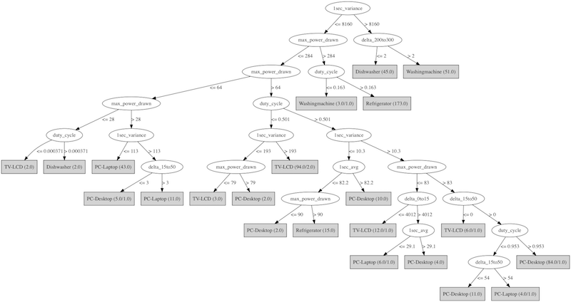
"The algorithm asks binary questions, then splits. For instance, 'Is the maximum power drawn less than 1,510 kilowatts? Yes. Okay, is it on less than 16 percent of the time? Yes. Does it have this or that? Yes. Okay, it's a dishwasher. Or, no, it's on more than 16 percent of the time. It's a refrigerator."
"About 40 percent of energy use in the US is residential. Even minute savings for a single homeowner would be worth it in the aggregate, assuming everyone had smart homes."
"Smart homes are a quickly growing field. Sometimes it's called the 'internet of things,' when you put many computers [or computerized devices] together."
"I like the idea of having the skills to do different things that interest me. I could go work for a farm and make it a smart farm. I could make apps in Boston, or go work for the government in research labs. There are so many things programming skills enable you to do."
Corinne Alini ’18 has a Rusack Coastal Studies Fellowship to create computer models that can predict flooding scenarios along the coast of Maine. Her advisors on the project were Associate Professor of Computer Science Laura Toma and Lecturer in Environmental Studies Eileen Johnson.
Alini, who is from Westchester, N.Y., missed five days of school after Hurricane Sandy struck her home in 2012.
"Hurricane Sandy...caused billions of dollars of damage [$75 billion] and loss of life [233 people died]. Experts inaccurately predicted the amount of damage from that hurricane. The flood maps had not been updated in a long time and most importantly they did not account for the rise of the sea level that has been recorded in the last century. Increased sea level brings storm surges further inland and causes increased flooding. We'd like to be able to model storm flooding that incorporates sea level rise. Many researchers have worked on this problem since Hurricane Sandy, using the widely-known software called ArcGIS. [But] the protocol for computing flooding in ArcGIS consists of many steps, is tedious, and most importantly is extremely slow on large, high-resolution data. So how do we actually model storm flooding more efficiently?"
"I thought it was an important problem, and it has a lot of impact. And it is an interesting computer science problem."
"The goal of my research was to develop a standalone module (outside of ArcGIS) that is able to compute flooding resulting from either sea level rise alone (the areas that would be under water if sea level rises by x feet?) or sea level rise on top of storm surges (the areas that would be flooded by storms plus x ft of sea level rise). I implemented a different and much faster algorithm that is able to efficiently work on high-resolution data. Ultimately the goal is to be able to predict various scenarios of sea level rise...for the whole coast of Maine."
"In summary, our program is simpler to run, it can compute arbitrary flooding scenarios and produces results that are practically the same as ArcGIS, it’s efficient, and it’s open source (on GitHub).
"It's really cool to do something that is meaningful, and I've been inspired by this project. I learned a lot about computer science and a lot about the environmental field."


Phillip Wang ’18 has a Surdna Foundation Undergraduate Research Fellowship to create a computer program that can scan satellite images around the globe and detect the looting of archaeological sites.
"The overall goal of my project is to develop a computer program that takes high-resolution satellite imagery and uses computer-vision algorithms to detect looting....You can train a computer to recognize so many things. I like to think you could train a computer to essentially detect pockmarked holes."
"I'm a computer science major and an archaeology minor, and have taken many classes with Professor [Jim] Higginbotham [associate professor of classics on the Henry Johnson Professorship Fund and associate curator for the Ancient Collection in the Museum of Art]. He inspired me to take on this project."
"In Professor Higginbotham's class Endangered Pasts, we talked a lot about how many archaeological sites are being endangered. The class went over the damage being done today and done in the past, and what we can do to prevent it, like using satellite images."
"The biggest problem is that…current methods for detecting archaeological looting using satellite imagery still need an element of human input. I’m trying to create a computer program that automatically detects looting.”
"The final dream of the vision is to automate a process where the computer can check images from Google Earth or can work through a database of images and continually go through them."
"I like computer science because it feels like you are creating something. You can type up a program and instantly see the results. And it helps when I'm mixing it with something I really like, like archaeology."